| Date: Sun, 8 Feb 2004 00:39:54
-0600
A "New" and Incredibly Powerful
Terrorist Weapon of Mass Destruction
Below is an article
on a possible indicator of a most serious strategic
potentiality, since it involves a
new kind of "weapons of mass destruction" (WMD) strategic
threat to the United States (and to
the entire Western world) as potent as an all-out nuclear
strike from Russia with the Russians
firing everything they've got. The actual weapon to be used is an old
weapon developed and deployed in the early 1960s, but with a novel
application.
From the article, it
seems something odd may be going on vis a vis quake reporting
also. If
this report is true, then the U.S. may
have deliberately refrained from reporting a fairly large quake
near the super caldera associated with Yellowstone.
This follows the same quake
reporting USGS folks removing from their
website a previously reported quake activity in the Bering straits.
If that Yellowstone quake was indeed
a manmade event, then someone (most probably the
Yakuza /Aum
Shinrikyo teams in Russia , using their scalar interferometers
leased from the Russians at
the end of 1989) could be tuning up a U.S. catastrophe of truly
gigantic proportions. If a sudden eruption
of that giant Yellowstone caldera were deliberately stimulated, there
would be hell to pay across the entire United
States and much of the world ,
with horrible results that could destroy North America and even
threaten the extinction of human life on earth.
The situation is further exacerbated by the fact that, in the view of
many geophysicists, the Yellowstone caldera is in a geological period
when just such a natural eruption could occur anyway. This means there
is lots of natural geological stress already on the caldera, rendering
it much easier to stimulate a very powerful eruption with catastrophic
consequences.
Note also the
proximity to the coming giant strategic Russian exercise. This may be
the communist-dominated faction of
the FSS/KGB (which controls the energetics superweapons)
allowing their lessee Yakuza client to participate in the planning
and preparation for that
strategic exercise.
In 1997 the U.S. government actually
confirmed the use of "electromagnetic weapons" to stimulate volcanoes
into eruption, control the weather, and induce earthquakes. One can
easily observe and photograph the ongoing weather engineering all over
the U.S., and particularly here in Huntsville ,
and we have published such results for decades . Here's a
statement by Secretary Cohen (then U.S.
Secretary of Defense) 1997 on the subject, in a direct quotation:
In addition to continuing to operate and
use their leased Russian interferometry weapons on site in
Russia, the Yakuza/Aum Shinrikyo also took the technology back to
Japan with them, and set up their own weapons
production facilities there. They apparently used them to kill
certain Japanese politicians opposing the Yakuza .
This was not an
activity of the Japanese government!
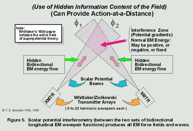
Scalar interferometry weapons theory originates from
the two Whittaker papers of 1903 and 1904, and the science is
rigorous, although it is not ordinary electrical engineering. The
former Soviet Union deployed the first strategic scalar interferometer
weapons in 1963, using one to kill the U.S.S. Thresher nuclear
submarine off the U.S. coast. To build scalar interferometry weapons,
one has to first develop longitudinal EM wave technology. To
see a rigorous theoretical
explanation of this kind of effect in higher group symmetry
electrodynamics, by a master theorist, see M. W. Evans et al., "On
Whittaker's Representation of the Electromagnetic Entity in Vacuo,
Part V: The Production of Transverse Fields and Energy by Scalar
Interferometry," Journal of New Energy, 4(3), Special Issue,
Winter 1999, p. 76-78.
The Yakuza
definitely should be accounted as a major though very clandestine world terrorist
organization, absolutely dedicated to the total destruction
of the United States. Because they have scalar interferometry
weapons, the Yakuza are
potentially much more deadly strategically than
the Al Qaeda. Those Yakuza scalar
interferometry weapons still operated on site in Russia are
under the direct operational control
of the KGB/FSS. We may be watching one more preparation by the Yakuza,
tuning up and doing an artillery registration with
these interferometry weapons to be able to initiate one or more
caldera events in the U.S. The
potential super caldera involved could be stimulated into an event
so catastrophic that it could
destroy America and even pose a threat to the extinction of all
humanity were such desired. For the
FSS/KGB to allow the Yakuza crews to set up that capability
would certainly pacify the Yakuza clamor
to directly participate in
any eventual destruction of the U.S. The Yakuza used these same
interferometers to shoot down the TWA-800, e.g.
and are using them right now to strongly engineer the weather over
North America and elsewhere.
There are at least two
other such calderas in the United States (see enclosed article s ),
which also could be targeted by Yakuza
hostile scalar interferometry.
If this quake
in Yellowstone is a deliberate warm-up test,
it should be closely followed by world
intelligence analysts as a possible "hostile registration" of
superweapons for what could then be a
highly unorthodox but terrible strategic strike on the
U.S. that could destroy the entire
nation in a single blow. Please read the enclosed articles,
which are just a small sampling of what such stimulation of one or
more caldera eruptions could do.
Again, the U.S. Secretary
of Defense publicly confirmed the hostile use of these weapons to
initiate quakes and stimulate volcanic eruptions. So
the weapons are known to be already being used in just
such fashion. The Yellowstone caldera is also known to be one of the
largest on earth, and capable of doing the damage to totally destroy
the U.S. and even much of the Earth. This is not foolishness,
but deadly serious information.
Tom Bearden
ADAS, Feb. 8, 2004
See response from USGS below - Webmaster Large Yellowstone
Area Quake Goes Unreported...02/07/04 Earth Changes TV exclusive! A 'large-moderate' 5.3 magnitude earthquake occurred in the Yellowstone Super-Volcano area yesterday, February 6th. It is posted on the European-Mediteranian Seismological Center (EMSC) site:http://www.emsc-csem.org/ When I posted this startling report in
yesterday's article:
http://www.earthchangestv.com/mitch/06mitch.php I was soon flooded
with emails telling me this earthquake has not been reported by the
United States Geological Survey (USGS) Did I stumble onto a cover-up? Is our government willfully omitting information which is known in all geological and seismological disciplines as a top rated priority? Was it simply an 'oversight'? This is a formal call to all governmental bodies. I am requesting your participation, and response to this potentially hazardous event. I promise equal and measured air time, and will provide a transcript for your records, and our audience. Please pass this delicate information to your news groups and friends. I am determined a possible cover-up shall not prevail. Here is my evidence: DATE TIME LAT LON DEP MAG AM NET REGION NAME 2004/02/06 19:03:33.3 43.5N 105.1W 264
mb5.3 A NEIA WYOMING DAT: 200402061923 GMT The following is an UNCHECKED,
FULLY AUTOMATIC LOCATION from the WYOMING ENAU dat = 6 FEB 2004 (
37) prelim nph = 22 of 33 se = 3.49 gap = 93.9 avh = 21.7 poor 80 km (50 miles) WSW of Newcastle,
Wyoming (pop 3,000) FE=460 PKP mb = 5.3 ( 2) ML = 0.0 ( 0) mblg = 0.0 ( 0) md = 0.0 ( 0) MS = 0.0r( 0) sta phase arrival res dist
azm amp per mag amp per mag sta Hypocenter records: Pub Flags: Generated 2004 FEB 6 at 19:18 UTC Reception date: 2004/02/06-19:23 Subscribe To ECTV For Full Access: http://www.earthchangestv.com/subscribe.htm Receive Your "Free" ECTV Newsletter: http://www.earthchangestv.com/newsletter.htm About Mitch: http://www.earthchangestv.com/mitch/index.htm Survival Tips:
http://www.earthchangestv.com/survival/index.htm Mitch Battros
resurgent calderas in US.htm
Date: Fri, 13 Feb 2004 07:56:48 -0700 Your website, and the page at http://www.cheniere.org/correspondence/020804.htm , were brought to my attention by a fan of yours.
Unfortunately Mitch Battros cannot read a map, and you have
uncritically passed along his erroneous information without doing
any fact checking. The coordinatesof the event listed on his, and
your website, 43.5N 105.1W, are nowhere near Yellowstone. This
location is in eastern Wyoming, approximately 270 miles from
Yellowstone. |